


MOVE-ME.AMP

คำอธิบายของMOVE-ME.AMP
** MOVE-ME.AMP ONLY WORKS IN OPORTO CITY **
MOVE-ME.AMP is a prototype of an application that allows mobile access to global and diversified information about public transports available in Oporto city.
Fully new in Portugal, MOVE-ME.AMP shares to the final user wide and spread information concerning several operators of public transports and allows planning our routes in real time with features like intermodality and real time.
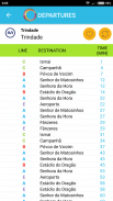
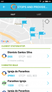
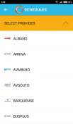
Nevertheless, the system allows finding the next departures, consulting the waiting times and destinations that are associated to next vehicles of a place chosen by the user.
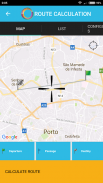
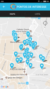
An integration of maps enables the user to define a localization providing information such as:
• What are the nearest stops?
• What are the nearest points of interest?
• When is the next vehicle to pass in this stop?
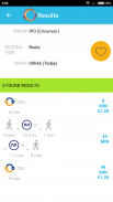
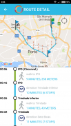
The route finder helps the user to find the best route to a specific place. The places can be bus stops, metro and train stations, points of interest and GPS localizations. The solutions given take into consideration the real time vehicle positions and return the best option for that moment. The system informs the passing time for each stop, the local place to change and walking route between them.
** ย้าย ME.AMP ทำงานเฉพาะใน Porto CITY **
ย้าย ME.AMP เป็นต้นแบบของโปรแกรมที่ช่วยให้เข้าถึงโทรศัพท์มือถือไปยังข้อมูลทั่วโลกและมีความหลากหลายเกี่ยวกับการขนส่งสาธารณะที่มีอยู่ในเมืองโอปอร์โต
ใหม่อย่างเต็มที่ในโปรตุเกสย้าย ME.AMP หุ้นให้กับผู้ใช้สุดท้ายกว้างและการแพร่กระจายข้อมูลเกี่ยวกับผู้ประกอบการหลายระบบขนส่งมวลชนและช่วยให้การวางแผนเส้นทางของเราในเวลาจริงที่มีคุณสมบัติเช่น intermodality และเวลาจริง
อย่างไรก็ตามระบบช่วยให้การหาขาถัดไปให้คำปรึกษาเวลาในการรอและสถานที่ท่องเที่ยวที่เกี่ยวข้องกับยานพาหนะต่อไปของสถานที่ที่ได้รับการแต่งตั้งโดยผู้ใช้
การบูรณาการแผนที่ช่วยให้ผู้ใช้ในการกำหนดให้การแปลข้อมูลเช่น:
•อะไรคือหยุดที่ใกล้ที่สุด?
•อะไรคือจุดที่ใกล้ที่สุดของที่น่าสนใจ?
•เมื่อเป็นรถต่อไปที่จะผ่านในหยุดนี้หรือไม่?
การค้นหาเส้นทางที่จะช่วยให้ผู้ใช้สามารถค้นหาเส้นทางที่ดีที่สุดไปยังสถานที่ที่เฉพาะเจาะจง สถานที่ที่สามารถเป็นป้ายรถเมล์, รถไฟใต้ดินและสถานีรถไฟจุดที่น่าสนใจและ GPS localizations การแก้ปัญหาให้คำนึงถึงเวลาจริงตำแหน่งยานพาหนะและกลับเลือกที่ดีที่สุดสำหรับช่วงเวลาที่ ระบบจะแจ้งเวลาที่ผ่านไปสำหรับการหยุดแต่ละสถานที่ในท้องถิ่นเพื่อการเปลี่ยนแปลงและเดินเส้นทางระหว่างพวกเขา
MOVE-ME.AMP--เวอร์ชั่น2.2.17
(01-02-2020)
MOVE-ME.AMP - ข้อมูล APK
เวอร์ชั่น APK: 2.2.17แพ็คเกจ: com.movemeเวอร์ชั่นล่าสุดของMOVE-ME.AMP
เวอร์ชั่นอื่น


แอปในประเภทเดียวกัน


